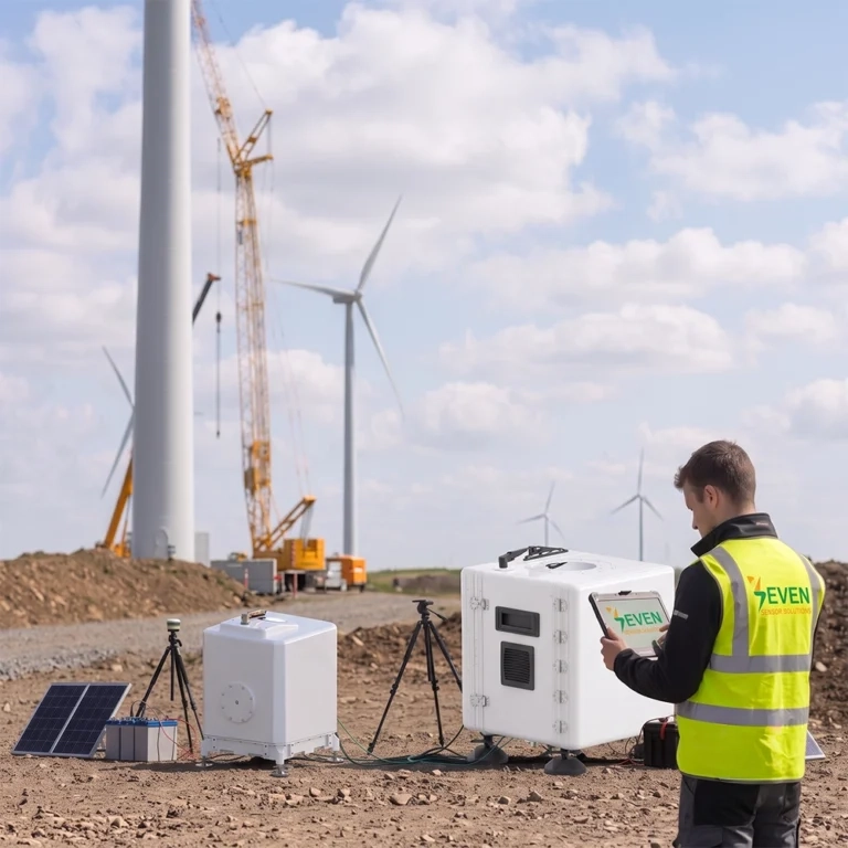
Wind LiDAR Rental Service
As an alternative to the old technology of met masts, which consume both time and budget, modern LiDAR has taken its place in the market to protect the two most precious factors in any project: time and money.
SEVEN Sensor now extends its meteorological expertise to wind remote sensing with a flexible wind LiDAR rental service for the wind energy sector.
Wind LiDAR: The Technology to Replace Masts
Wind LiDAR has emerged as the most cost-efficient means to assess the wind resource at current hub heights, and its measurements are recognized by the industry and financing banks for renewables projects. Rented rather than owned, this technology becomes available precisely when the project needs it.
SEVEN supplies a variety of Wind LiDAR according to client needs. In most projects, we recommend one of two proven pulsed Doppler vertical-profiling systems, described below by type and capability.
Rent or Purchase a Wind LiDAR
Purchasing a LiDAR unit can be considered an expensive investment, especially for wind projects that only need measurement for a defined period of time, generally 3 to12-months either for resource assessment or a power performance testing. Renting matches the cost to the actual need and removes the burden of long-term ownership. For developers, consultants, or operators who run repeated campaigns, purchasing the LiDAR is often the better long-term value, and SEVEN supplies both options.
Renting is well suited to a defined measurement period of time as it offers:
- No significant capital outlay
- Equipment availability according to the schedule needed by the project
- No need for permission, foundations and other civil works like in case of met masts
- Quick deployment and redeployment between different sites
- Equipment maintenance by SEVEN
- Bankable and certified data
What the Rental Service Includes
Depending on the offered service, the rental package may cover:
- Power requirement (grid, solar or hybrid power arrangement, based on the site requirement)
- Connectivity and cloud access
- Installation and commissioning services
- Setting of measurement heights according to your rotor/hub dimensions
- Supply of data in industry accepted format
- Remote monitoring, technical and maintenance services during the rental period
- Optional site assessment and reporting support
Available LiDAR Types
SEVEN recommends two vertical-profiling wind LiDARs. These are both pulsed Doppler instruments that will take the place of a high met tower and provide information on wind speeds throughout the full rotor sweep height.
Type A: Pulsed Doppler Vertical Profiler (Reference / Bankable Class)
This is a common type of vertical profiling wind LiDAR with a history of reliable bankable, accepted information for utility-scale wind projects.
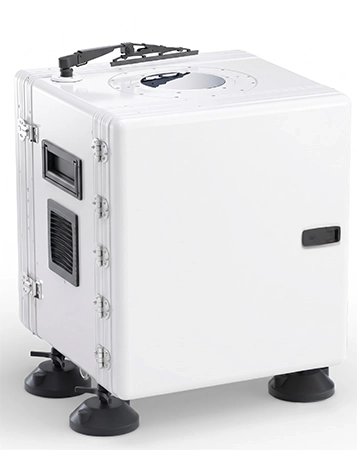
| Parameter | Specification |
| Technology | Pulsed Doppler LiDAR (DBS, 5-beam) |
| Measurement range | 40 m to 300 m |
| Simultaneous heights | Up to 20, measured every second |
| Wind speed accuracy | 0,1 m/s |
| Data provided | Wind speed, wind direction, turbulence intensity, vertical wind speed, data availability |
| Compliance | IEC-classified; pre-validated units available |
| Software | Cloud-based data and fleet-management platform |
| Best for | Bankable resource assessment, complex terrain, onshore and offshore utility-scale projects |
Type B: Pulsed Coherent Doppler Vertical Profiler (Extended Range)
Compact “wind-tower-replacement” vertical profiling system that uses less power and has an extended range of measurement; a strong value option for resource assessment and power-curve work.
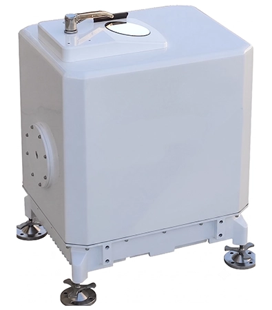
| Parameter | Specification |
| Technology | Pulsed coherent Doppler Wind LiDAR |
| Measurement range | 40 m to 350 m |
| Height gates | Up to 24 selectable gates |
| Range resolution | ± 1 m; second-level data refresh |
| Wind speed accuracy | ≤ 0,1 m/s |
| Data provided | Instantaneous and time-averaged wind speed/direction, vertical speed, min./max. horizontal wind speed, turbulence intensity, wind shear index, SNR, GNSS position and time, LiDAR status |
| Compliance | Designed and manufactured to IEC 61400-12-1 |
| Best for | Wind resource surveying, power-curve testing, wind forecasting, complex-terrain shear analysis |
Please note that the above-mentioned specifications are indicative. Final specifications are confirmed against the datasheet of the unit supplied for your campaign.
Choosing Between the Two Types of LiDAR
Both types have 0,1 m/s accuracy for measuring the rotor-sweep profile. In a general sense:
- Type A is chosen in situations when an officially certified, completely bankable data set is needed; e.g., project finance, contractual power-performance testing.
- Type B provides a long-range capability up to 350 m and a highly economic package for resource assessment and measurement campaigns.
SEVEN will help you choose the appropriate type depending on the topography, hub height, length of the campaign and reporting needs.
Applicable Standards for Wind LiDARs
Wind LiDAR campaigns performed by SEVEN are according to the internationally acknowledged standards for remote-sensing wind measurement:
- IEC 61400-12-1: power performance measurements of electricity producing wind turbines
- IEC 61400-50-2: using ground-based remote sensing devices (RSD) for wind measurement
- MEASNET: procedures for evaluation of wind measurement
- DNV: practices and guidelines for classification/ validation of LiDARs
- OWA (Offshore Wind Accelerator): offshore & floating LiDAR roadmap
Flexible Rental Terms of LiDAR
The rental can be configured according to the demands of your project rather than the other way around:
- A short-term rental for a test run or single measurement period.
- A long-term rental covering an entire campaign that takes months or even up to a year.
- Both onshore and offshore installations, depending on your needs and with the right power and communication capability.
The specific combination of LiDAR, rental period, power supply, connectivity, and level of support is determined taking into account your application, site conditions and objectives.
Why rent LiDAR through SEVEN?
In the capacity of an expert in meteorological instrumentation, SEVEN provides the same level of professionalism in wind LiDAR as they do in their solar and environmental sensors. Rental with SEVEN comes with the assurance that the instrument is properly calibrated and technical support is available for the duration of the mobilization until data delivery.
SEVEN offer you a tailored wind LiDAR solution, together with a customized quote.
Please get in touch with us for your wind LiDAR rental planning.
Frequently Asked Questions (FAQ) about Wind LiDAR Rental
What is a wind LiDAR?
A wind LiDAR is a ground-based instrument that uses a laser beam to calculate wind speed and direction at several different heights from the instrument rather than a meteorological mast.
Why should I rent a LiDAR and not buy it?
Almost all of the projects require the data to be collected for a certain time period. The rental cost reflects this fact and is more convenient since it is not a big capital investment and does not imply any maintenance or calibrations.
Is it possible to buy a LiDAR, rather than rent it?
Yes. SEVEN provides the opportunity to either rent or buy LiDARs. Purchasing usually makes more sense for organizations running measurement campaigns repeatedly or continuously and SEVEN will help you to decide which one is better for you.
Which LiDAR models can be offered by SEVEN?
SEVEN usually recommends two models of pulsed Doppler vertical profilers - reference/bankable grade and extended range model – and helps you to choose which one suits you better. Make and model are defined during proposal preparation.
Which heights can be profiled?
Both the reference-class and the extended-range profiler allow measurement between 40 m and 300 m and 350 m, respectively, on multiple heights covering the entire rotor sweep range.
Is LiDAR acceptable for banking and certification purposes?
Yes. Classified and properly installed vertical-profiling LiDAR data are accepted for financing and certification purposes according to IEC 61400-12-1 and IEC 61400-50-2.
What is the measurement accuracy?
Accuracy of the proposed measurement devices is 0.1 m/s for the wind speed.
Can LiDAR be used in case of complex terrain?
Yes. Both LiDAR types are used for analysis of wind shear and wind resources in case of complex terrain when necessary.
Do you offer installation and support services?
Yes. The offered rental includes support in commissioning, monitoring, maintenance, and technical consultancy for the duration of the campaign.
Do you support offshore campaigns?
Yes. Offshore or floating installations are possible with corresponding powering, communication, and attitude-correction solutions where necessary.
How can I buy or rent Wind LiDAR?
Contact our sales team and share your requirements and project details. Our team will be happy to discuss your project and recommend the solution best suited to your needs.